categories
- Traffic and Vehicles Catalogue
- socreal.catalog
- Advertisement Catalogue
- Photo Catalogue
- Chinese and Japanese Catalogue
- New Holy Card Catalogue II.
- 12 interesting old books
 Books
Books
 Bibliophil
 Antiques
 Engraving
 Maps
Maps
 Photos
 Antique Papers, Small Prints
 Posters
- Circus
- Modern Graphics
- Socialist Realism
- NER Propaganda
- Others
cart
Cart is empty
You've not logged in
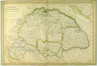
Lowry, Joseph Wilson : HUNGARY, Transylvania, Dalmatia - and the Military Frontiers (Croatia, Sclavonia, & Banat.)
- description
- additional information
Copper engraving, original outline colour. Published in The Imperial Atlas of Modern Geography. Size: 36 x 54 cm.
XIX. századi Magyarország térkép katonai határvonalakkal.
Megjelent: The Imperial Atlas of Modern Geography.
Acélmetszet, eredeti határszínezéssel, 36 x 54 cm., középen hajtásnyom.
Megjelent: The Imperial Atlas of Modern Geography.
Acélmetszet, eredeti határszínezéssel, 36 x 54 cm., középen hajtásnyom.


 Telefon:
 E-mail:


