categories
- Traffic and Vehicles Catalogue
- socreal.catalog
- Advertisement Catalogue
- Photo Catalogue
- Chinese and Japanese Catalogue
- New Holy Card Catalogue II.
- 12 interesting old books
 Books
Books
 Bibliophil
 Antiques
 Engraving
 Maps
Maps
 Photos
 Antique Papers, Small Prints
 Posters
- Circus
- Modern Graphics
- Socialist Realism
- NER Propaganda
- Others
cart
Cart is empty
You've not logged in
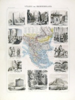
Türkei und Griechenland. (Illustrirter Handatlas No. 17.)
- description
- additional information
Törökország és Görögország színezett lith. térképe körül f-f életképekkel, megjelent: Leutemann, Heinrich (Mitarb.): Illustrierter Handatlas für Freunde der Erdkunde und zum Gebrauch beim Unterricht. Leipzig, 1863. Brockhaus.
37×51 cm.


 Telefon:
 E-mail:


