categories
- Traffic and Vehicles Catalogue
- socreal.catalog
- Advertisement Catalogue
- Photo Catalogue
- Chinese and Japanese Catalogue
- New Holy Card Catalogue II.
- 12 interesting old books
 Books
Books
 Bibliophil
 Antiques
 Engraving
 Maps
Maps
 Photos
 Antique Papers, Small Prints
 Posters
- Circus
- Modern Graphics
- Socialist Realism
- NER Propaganda
- Others
cart
Cart is empty
You've not logged in
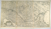
Merian, Matthaus : Totius Regni Hungariae, Maxim ae que Partis Danubii Fluminis, una cum adjacentibus et finitimis Regionibus
- description
- additional information
Magyarország rézmetszetű térképe, kibővítve a Fekete-tengerig terjedő résszel.
Az ábrázolás szinte teljesen megegyezik Visscher 1657-ben megjelent lapjával. Megjelent először 1660-ban J. L. Gottfried "Vermehrte Archontologia Cosmica" című munkájában, Matthaeus Merian örökösei kiadásában.
Kétlemezről nyomva , a megfelelő helyen illesztve.
Ép, szép példány, bár kissé halvány nyomású.


![Merian, Matthäus : Spilberg [Osztrák település] Merian, Matthäus : Spilberg [Osztrák település]](/images/item_image/100/162413.jpg)
![Merian, Matthäus : La Motte [La Mothe-en-Bassigny] Merian, Matthäus : La Motte [La Mothe-en-Bassigny]](/images/item_image/100/162535.jpg)

![Merian, Matthäus : Cales - Calais - Duynkerke [Calais és Dunkerque] Merian, Matthäus : Cales - Calais - Duynkerke [Calais és Dunkerque]](/images/item_image/100/162543.jpg)
![Merian, Matthäus : Cassellae - Cassel [Kassel] Merian, Matthäus : Cassellae - Cassel [Kassel]](/images/item_image/100/162555.jpg)


![Merian, Matthaus : Augusta Vindelicorum - Auspurg [Augsburg] Merian, Matthaus : Augusta Vindelicorum - Auspurg [Augsburg]](/images/item_image/100/162786.jpg)


 Telefon:
 E-mail:


