categories
- Traffic and Vehicles Catalogue
- socreal.catalog
- Advertisement Catalogue
- Photo Catalogue
- Chinese and Japanese Catalogue
- New Holy Card Catalogue II.
- 12 interesting old books
 Books
Books
 Bibliophil
 Antiques
 Engraving
 Maps
Maps
 Photos
 Antique Papers, Small Prints
 Posters
- Circus
- Modern Graphics
- Socialist Realism
- NER Propaganda
- Others
cart
Cart is empty
You've not logged in
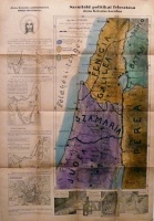
Szentföld politikai felosztása Jézus Krisztus korában
- description
- additional information
Rajzolta: Dvornitzky Péter.
A Szentföld térképét Dr. Pataky Arnold a Pázmány Péter tudományegyetem rendes tanára állította össze.
Oldalt kis térképek pl.: Jeruzsálem, A szent család útjai stb. Offset, méret: 100 x 70 cm., hajtogatva, hiánytalan, szép állapotban.
A Szentföld térképét Dr. Pataky Arnold a Pázmány Péter tudományegyetem rendes tanára állította össze.
Oldalt kis térképek pl.: Jeruzsálem, A szent család útjai stb. Offset, méret: 100 x 70 cm., hajtogatva, hiánytalan, szép állapotban.
| condition: |     |
| category: | Maps > Countries outside of Europe > |
| category: | Books > Religion > |
| publisher: | Ferences Tudományfőnökség, é.n. (ca.1940-es évek). Budapest, (Kapisztrán Ny., Vác,), |
| item number / ISBN: | 0056077 |
| language: | Hungarian |


 Telefon:
 E-mail:


