categories
- Traffic and Vehicles Catalogue
- socreal.catalog
- Advertisement Catalogue
- Photo Catalogue
- Chinese and Japanese Catalogue
- New Holy Card Catalogue II.
- 12 interesting old books
 Books
Books
 Bibliophil
 Antiques
 Engraving
 Maps
Maps
 Photos
 Antique Papers, Small Prints
 Posters
- Circus
- Modern Graphics
- Socialist Realism
- NER Propaganda
- Others
cart
Cart is empty
You've not logged in
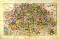
Magyarország politikai térképe
- description
- additional information
Mérték: 1:2300.000
Tervezte: Czakó István
A történelmi Magyarország és a trianoni határ bejelölve, színezett.
A térkép mérete: 43 x 23 cm.
Hajtva.
A hajtások mentén kis lyukak, szakadások.
Foltos, viseltes állapotban.
A történelmi Magyarország és a trianoni határ bejelölve, színezett.
A térkép mérete: 43 x 23 cm.
Hajtva.
A hajtások mentén kis lyukak, szakadások.
Foltos, viseltes állapotban.
| condition: |    |
| category: | Maps > |
| category: | Antique Papers, Small Prints > politics > |
| publisher: | Magyarí Földtani Intézet R.T., 1927 |
| item number / ISBN: | 0051152 |
| binding: | other (see in details) |
| language: | Hungarian |


 Telefon:
 E-mail:


