categories
- Traffic and Vehicles Catalogue
- socreal.catalog
- Advertisement Catalogue
- Photo Catalogue
- Chinese and Japanese Catalogue
- New Holy Card Catalogue II.
- 12 interesting old books
 Books
Books
 Bibliophil
 Antiques
 Engraving
 Maps
Maps
 Photos
 Antique Papers, Small Prints
 Posters
- Circus
- Modern Graphics
- Socialist Realism
- NER Propaganda
- Others
cart
Cart is empty
You've not logged in
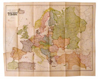
Gessner's, Anton : Karte von Europa - mit den neuen Staatengrenzen. 1920.
- description
- additional information
Maßstasse: 1:6.700.000.
Litografált térkép, méret: 70.5 x 88 cm.
Hajtogatva, a védőboríték szélein beszakadások, a hátsó boríték elvált, hiánytalan, szép állapotban.
| condition: |     |
| category: | Maps > European country > |
| publisher: | Moritz Perles, 1920. Wien, |
| item number / ISBN: | 0057340 |
| language: | German |


 Telefon:
 E-mail:


