categories
- Traffic and Vehicles Catalogue
- socreal.catalog
- Advertisement Catalogue
- Photo Catalogue
- Chinese and Japanese Catalogue
- New Holy Card Catalogue II.
- 12 interesting old books
 Books
Books
 Bibliophil
 Antiques
 Engraving
 Maps
Maps
 Photos
 Antique Papers, Small Prints
 Posters
- Circus
- Modern Graphics
- Socialist Realism
- NER Propaganda
- Others
cart
Cart is empty
You've not logged in
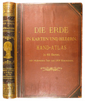
Die Erde in Karten und Bildern. Hand-Atlas in 63 Karten nebst 125 Bogen Text mit 1000 Illustrationen.
- description
- additional information
Az előzéklapon -golyóstollas- ajándékozási sorokkal.
Restaurált, javított félbőrkötésben.
Restaurált, javított félbőrkötésben.
| condition: |     |
| category: | Books > Foreign Language Books > Books in German > |
| category: | Books > Geography > |
| category: | Maps > |
| publisher: | A. Hartleben's Verlag, 1889 |
| item number / ISBN: | 0049502 |
| binding: | other (see in details) |
| pages: | VIII, 494, 63 (Karten) |
| language: | German |


 Telefon:
 E-mail:


